Landslide Monitoring Systems – Real-Time Slope Stability with IoT Sensors

Landslide monitoring systems play a critical role in protecting infrastructure, investments, and human lives, especially in regions prone to heavy rainfall, seismic activity, or rapid urban development. With the advancement of IoT technology, landslide monitoring systems now enable real-time data collection, automated alerts, and predictive analysis to detect slope instability early and prevent catastrophic failures.

1.Why landslide monitoring matters?

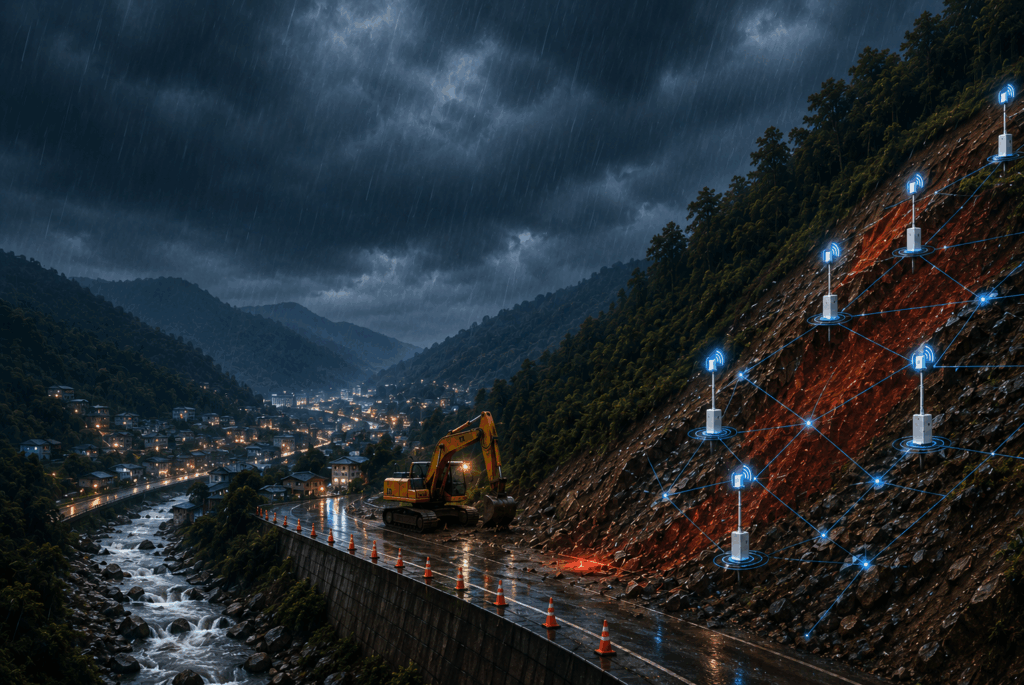
Landslides are critical geotechnical hazards that often occur suddenly but are usually preceded by detectable warning signs. Key triggers include heavy rainfall, which saturates the soil and reduces its strength; seismic activity, which destabilizes ground structures; construction vibrations from excavation or piling; and changes in groundwater levels, which increase pore pressure and weaken soil stability. When these factors combine, the risk of slope failure rises significantly.

The consequences of landslides can be severe in both economic and safety terms. They can cause major infrastructure damage to roads, bridges, and buildings, disrupt ongoing projects, and lead to significant financial losses. More importantly, landslides pose serious risks to nearby communities, threatening lives and creating long-term environmental and social impacts if not properly managed.

To effectively assess and mitigate these risks, a landslide monitoring system focuses on three key parameters:

  • Tilt: Detects slope movement and deformation, helping identify early signs of instability
  • Pore pressure: Reflects groundwater conditions that directly influence soil strength and slope stability
  • Rainfall: A key triggering factor that increases soil saturation and the likelihood of landslides

2. Sanlien landslide monitoring solution

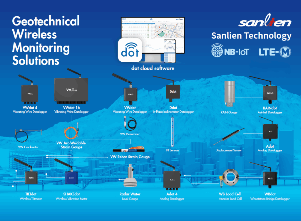
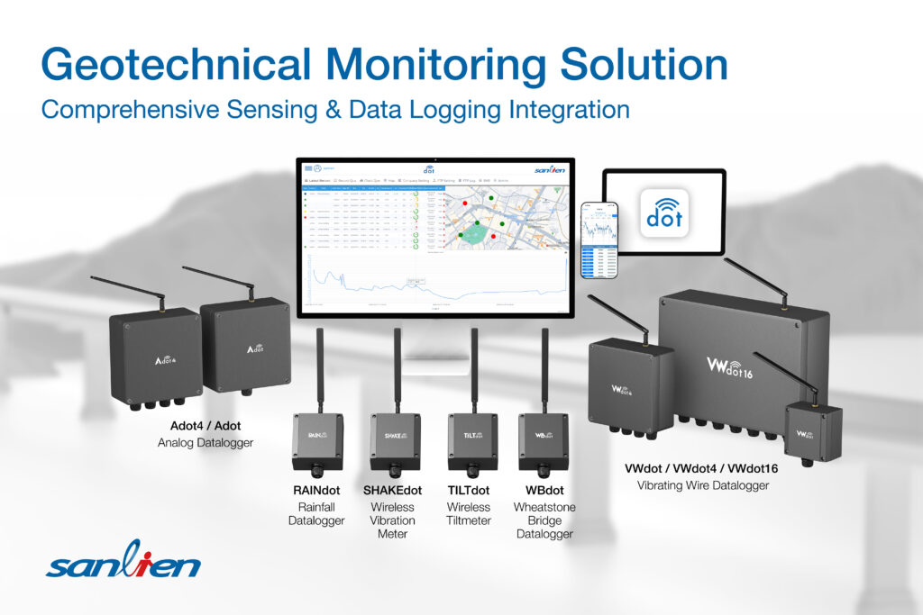
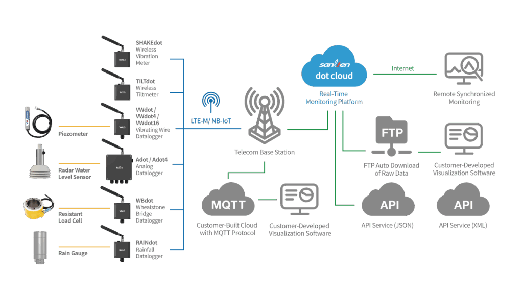
Sanlien provides a comprehensive, LTE-M and NB-IoT-based landslide monitoring system that integrates advanced sensors, wireless data transmission, and cloud-based analytics.

2.1 Geotechnical sensors for slope & Soil measurement

A reliable landslide monitoring system depends on high-precision geotechnical sensors that continuously measure ground behavior both at the surface and below ground. These sensors provide critical data on deformation, pressure, and environmental conditions, helping engineers assess slope stability and detect early signs of failure.

Sanlien’s solution integrates a comprehensive set of advanced sensors:

  • MEMS Tiltmeter: Measures surface tilt and structural rotation with high sensitivity, enabling early detection of slope movement and deformation. MEMS technology allows compact, robust, and real-time monitoring of angular changes.
  • MEMS In-Place Inclinometer (IPI): Installed in boreholes to continuously monitor subsurface lateral displacement. This sensor array provides real-time data on soil movement at different depths, essential for tracking deep-seated slope instability.
  • VW (Vibrating Wire) Piezometer: Designed to measure pore water pressure and groundwater levels within soil and rock. These readings are critical for evaluating slope stability, as increased pore pressure can significantly reduce soil strength.
  • VW Earth Pressure Cell: Measures total earth pressure and stress within soil layers or structures, helping engineers understand load distribution and soil behavior under changing environmental or construction conditions.
  • RAINdot (Rain Gauge): Monitors rainfall intensity and accumulation, one of the primary triggering factors of landslides. Correlating rainfall data with ground movement improves prediction accuracy and enhances early warning capability.
2.2 Wireless IoT dataloggers

A modern landslide monitoring system requires reliable and efficient data acquisition and communication. Wireless IoT dataloggers serve as the central interface between geotechnical sensors and cloud platforms, enabling continuous data collection without the need for complex cabling infrastructure. These devices ensure that critical monitoring data is transmitted seamlessly from the field to remote monitoring centers.

Sanlien’s solution incorporates a versatile range of IoT dataloggers:

  • TILTdot: Designed for tilt and angular measurements, enabling direct integration with MEMS tilt sensors for real-time slope movement monitoring.
  • VWdot, VWdot4, VWdot16: Specialized dataloggers for vibrating wire sensors, supporting multiple channels to measure parameters such as pore water pressure and earth pressure across different locations simultaneously.
  • RAINdot: Dedicated to rainfall monitoring, capturing precipitation intensity and accumulation data for correlation with slope stability conditions.
  • Adot4: Supports analog signal inputs, allowing flexible integration with various third-party sensors and expanding system compatibility.

2.3 dot Cloud

An effective monitoring system requires not only accurate data collection but also powerful tools for data processing, visualization, and decision-making. dot Cloud is a cloud-based geotechnical monitoring platform that centralizes all data from IoT sensors and dataloggers into a single, integrated environment.

The platform provides a real-time monitoring dashboard, offering engineers continuous visibility into slope behavior and infrastructure conditions. This enables faster interpretation of field data and supports timely, data-driven decision-making for risk mitigation.

Key features of dot Cloud include:

  • Real-time Data Integration: Aggregates and synchronizes data from multiple sensors and sites into one unified system.
  • Threshold-based Alerts: Automatically triggers warnings when monitored parameters exceed predefined limits, with notifications sent via SMS to ensure rapid response.
  • Advanced Visualization: Presents data through intuitive charts, graphs, and dashboards, making it easier to analyze trends and detect anomalies.
  • Historical Data Tracking: Stores long-term monitoring data for trend analysis, performance evaluation, and reporting.
  • Multi-site Management: Enables users to monitor and manage multiple projects simultaneously from a scalable cloud platform.

3. Key features of Sanlien’s landslide monitoring system

Sanlien’s landslide monitoring system is designed as a fully integrated geotechnical solution that combines IoT sensing, wireless communication, and cloud-based data management to deliver reliable and real-time slope safety monitoring.

  • Real-time monitoring and early warning: threshold-based alerts, SMS/email/API notification via dot Cloud. The system continuously tracks ground conditions and automatically triggers warnings when predefined safety limits are exceeded, enabling fast response to potential slope failures.
  • NB-IoT & LTE-M wireless connectivity: no need for long cable installation, allowing fast deployment in remote and hard-to-access terrain. This wireless architecture ensures stable data transmission even in challenging field environments.
  • Low-power autonomous operation: powered by solar panels or rechargeable batteries, ensuring high uptime even during power outages. This supports long-term continuous monitoring with minimal maintenance.
  • Multi-parameter integration: combines key geotechnical parameters including tilt, pore pressure, and rainfall in a single platform, providing a comprehensive view of slope behavior and stability conditions.
  • Scalable from single slope to multi-site network: supports expansion from one monitoring point to large-scale networks, with VWdot16 enabling up to 16 channels and dot Cloud managing multiple projects simultaneously for centralized control.

4. How does Sanlien landslide monitoring work?

Sanlien’s landslide monitoring system is built on an integrated geotechnical IoT architecture that combines sensors, wireless dataloggers, and the dot Cloud platform to enable real-time slope safety management and early warning capabilities.

Sanlien’s system enables real-time landslide monitoring and early warning using IoT and cloud technology.

  • Step 1 – Site Assessment: The process begins with evaluating the site conditions, including terrain characteristics, soil properties, and historical landslide activity, to determine optimal sensor placement for effective monitoring.
  • Step 2 – Sensor Installation: Geotechnical sensors are deployed on-site, such as TILTdot or MEMS Tiltmeter installed on poles or structures, and VW Piezometer placed in boreholes to measure subsurface conditions like pore water pressure.
  • Step 3 – Wireless Network Setup: Wireless dataloggers such as VWdot or TILTdot are configured using NB-IoT or LTE-M connectivity and linked to the dot Cloud platform, enabling stable and real-time data transmission without extensive cabling.
  • Step 4 – Monitor & Alert: Once the system is operational, engineers set threshold values for key parameters. The system continuously monitors slope behavior and sends real-time alerts via dot Cloud when abnormal conditions occur, along with reporting and data export for further analysis.

5. FAQ

How does NB-IoT & LTE-M improve slope monitoring?

NB-IoT & LTE-M enables low-power, long-range wireless data transmission, allowing real-time monitoring without complex cabling and supporting deployment in remote areas.

What is the difference between TILTdot and a wired tiltmeter?

TILTdot is wireless with NB-IoT/LTE-M connectivity and sends data directly to cloud, while a wired tiltmeter requires physical cabling for data transmission.

How often does data update in real-time landslide monitoring?

Data can be transmitted at short intervals, depending on system configuration, enabling continuous monitoring via dot Cloud.

Can the system integrate with existing third-party platforms?

Yes, the system supports API-based connectivity, enabling seamless integration with a wide range of third-party monitoring and data management platforms.


Beyond traditional slope observation, landslide monitoring systems represent a shift toward data-driven geotechnical safety, where real-time sensing and intelligent alerts play a key role in preventing disasters before they occur. By combining IoT technology, wireless connectivity, and cloud-based analytics, Sanlien’s solution empowers engineers to move from reactive responses to proactive risk management, ensuring safer infrastructure development and more resilient communities in high-risk areas.